DECEMBER 2007 FLOOD IN NORTHWEST OREGON AND WESTERN WASHINGTON
Executive Summary
Two days of intense precipitation coupled with low to mid-level snowmelt caused flooding on 30 rivers in northwest Oregon and western Washington. The most severe flooding occurred on rivers from the central Oregon coast to the Olympic Peninsula (see figure 1). Record stage heights were recorded on the Chehalis, Skokomish and Elwah rivers. The towns of Vernonia, Oregon and Centralia, Washington were especially hard hit by the flooding. Flood waters forced the closure of Interstate 5 at Centralia, the main road between Portland and Seattle, for 4 days. In addition to severe flooding hurricane force winds associated with this event caused wide-spread damage to coastal areas.
Indications that a high magnitude storm could affect the NWRFC service area, were noted in the Hydrometeorological Discussion (HMD) 7 days prior the landfall. Flooding for this event was forecasted on the Skokomish River 4 days prior to the event. Flood forecast lead time was shorter at other locations, but flooding was forecasted at least 24 hours prior to occurrence. Although flooding was forecasted, the extreme magnitude of the event was more difficult to capture. The Doty gage in headwaters of the Chehalis Basin, which was flowing 10 feet above the previous record, provided valuable information used to produce timely, accurate forecasts of severe flooding downstream at Centralia, Grand Mound and Porter.
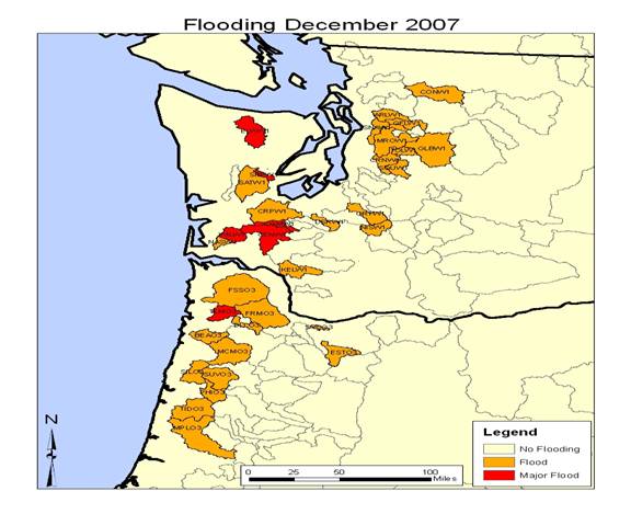
Figure 1 NWRFC forecast points that experience flooding in early December 2007.
This was the first major event where GFE was used as the primary tool to generate the quantitative precipitation forecasts (QPF) at the NWRFC. As would be expected the RFC day 1 precipitation forecasts were generally the most accurate, showing an incremental improvement over days 2 and 3. For this event, daily precipitation for sites that received less than 4 inches were forecasted with a reasonable degree of accuracy. Precipitation forecasts for points that received more than 4 inches were generally under forecasted. The degree of under forecasting increased with higher magnitude sites. In addition to this general low bias in the QPF, it was shown that NWSRFS simulations tended to under forecast these extreme events.
Low and mid-elevation snow melt contributed to the severity of the flooding. Although little snow was on the ground prior to the storm, data from the limited number of sites available indicates that there was a significant amount of snow accumulation during the first day of the event. Rapid ablation of the snow makes it difficult to ascertain the areal extent of the snow pack and thus the influence on the runoff rate.