When NWSRFS, SEUS and Snow Intersect
by
Vernon C. Bissell(1)
Abstract
The National Weather Service River Forecast System (NWSRFS) is being implemented for river and water supply forecasting operations by the National Weather Service in the Pacific Northwest. The initial process of calibration has been performed only by optimizing on the observed streamflow rather than on snow observations. The Snow Estimation and Updating System (SEUS) is a postprocessor which permits snow observations to be incorporated to update model states as the season progresses. The applicability of the NWSRFS suite of programs for water supply forecasting will be impacted by (1) reliability of data observations, (2) the cognitive value of the snow and soil moisture accounting conceptualizations, (3) the effect of daily operational changes ("modifications") made to the model to keep it tracking observed streamflow, and (4) the "connectivity" between SEUS and the realism with which the snow simulation duplicates reality. An example of Dworshak Reservoir (Idaho) inflow forecasts suggests the technique is very promising despite difficulties.
Introduction
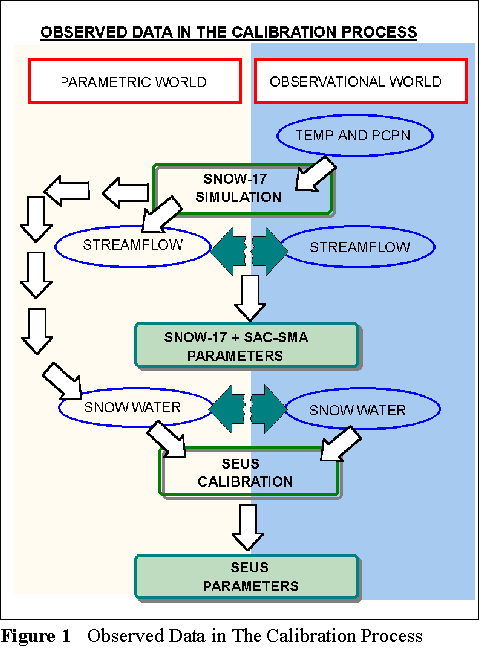
The National Weather Service River Forecast System (National Weather Service, 1972) is now being implemented by the National Weather Service River Forecast Center in Portland, Oregon, for application in the Pacific Northwest (Bissell and Orwig, 1995; Laurine et al., 1996). One primary objective of conversion to the NWSRFS suite of programs is the ability to model the "full hydrograph". That is, the model must be able to simulate sharp rises due to rainfall events, to accumulate and deplete snowcover for seasonal water supply forecasting, and provide significant skill in drought situations. In other words, the desire is to improve cognitive value of the modeling for critical extreme events (floods and droughts) as well as to extend the skill of forecasting further in time into the future. A key concern is "What is the information base by which the model is calibrated?" The answer is: basin mean six-hourly precipitation, basin daily maximum and minimum temperatures, monthly mean discharge, and daily mean discharge. In present procedures, basic snow information only enters the calibration process in developing SEUS parameters used to update basin snow water equivalent at the first of each month during the late winter and early spring period. See figure 1.
Snow Modeling In The Calibration Process
Reference to Table 1 shows the typical progression of calibration steps in basins of northwest Washington. These basins are characterized by heaviest precipitation falling in the winter period October through February, with accumulation of snow pack in the higher elevations and periods of flooding due to runoff in middle and lower elevations (generally below 4000 feet). Seasonal snowmelt depletion is the major source of discharge from mid-spring on through the summer.
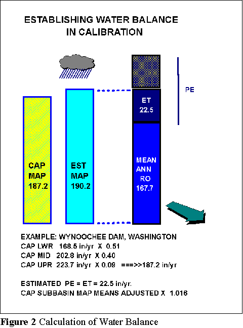
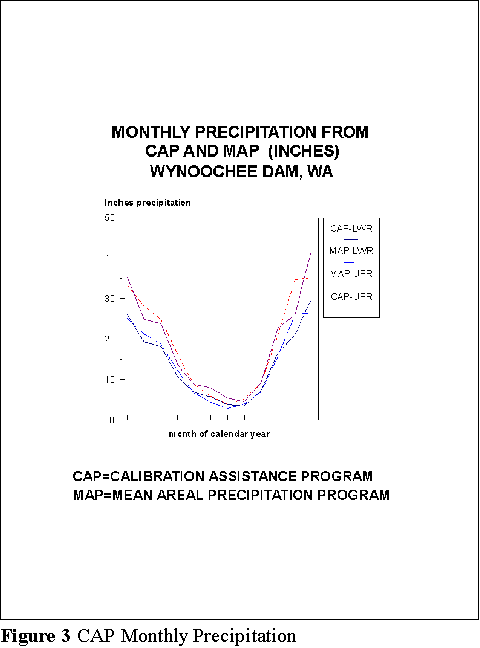
The first objective is to get a decent annual water balance based on measured precipitation, measured runoff, and estimated evapotranspiration (ET). In mountainous basins where more than one sub-basin is used to represent a single measured basin, the process is complicated by having to guess the distribution of precipitation input to each of the subareas to obtain the water balance. The process here is: (a) run the NWS Calibration Assistance Program (CAP) (NWS, NOHRSC,1995); the CAP uses a GIS based system to estimate the normal monthly precipitation in each basin sub-area, and thus normal annual for each sub-basin. (b)adjust the sub-basin normals by a factor to match the annual water balance. (c) use the annual sub-basin normals to adjust mean monthly precipitation values input to the Mean Areal Precipitation (MAP) program. Six-hourly precipitation is then computed for the calibration period. The water balance (with adjustment) for Wynoochee Dam inflow is shown in Figure 2. The comparison of the CAP monthly mean precipitation values and the Map monthly mean values for the "upper" and "lower" sub-basins is in Figure 3.
Table 1.   Progression of Calibration by Data Source


Seasonal Water Balance

     SNOW-17: SCF

     SAC-SMA: PXADJ, ET Demand


Mean Monthly Flows

     SNOW-17: PXTEMP, SCF, Lapse Rates, MFMAX and MFMIN, SI (100% Snow Above), Areal Depletion Curve

     SAC-SMA: PXADJ, ET Demand, LZFPM, LZPK, LZFSM, LZSK


Mean Daily Flows

     All SAC-SMA Parameters, Untigraph, then iterate all parameters


Six-Hourly Flows (if storm hydrographs are used)


Unitgraph, SAM-SMA Parameters
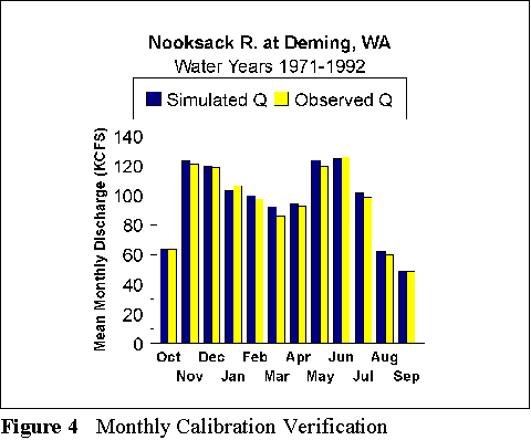
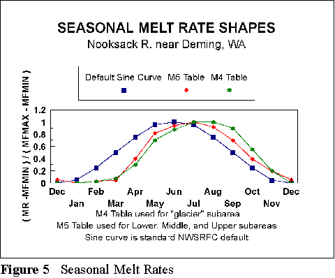
The next objective is to get a decent annual hydrograph of mean monthly simulated discharge. As the MAP is input to the model, further adjustments can be made in two places. The precipitation adjustments factor (PXADJ) parameter in the Sacramento Soil Moisture Accounting Model (SAC-SMA) is varied for sub-basins at the same time that the Snow Correction Factor (SCF) is modified for the Snow Accumulation and Ablation Model (SNOW-17) to try to get the most reasonable annual hydrograph of mean monthly flows. The PXADJ parameter is simply a factor by which all precipitation input is multiplied, usually 0.90-1.00. The SCF parameter is a factor applied to all precipitation input categorized as snow, usually 1.1-1.4. If further adjustment is needed, then other SNOW-17 parameters are "tweaked", such as, PXTEMP (air temperature at which precipitation is classified as snow or rain), lapse rates, and the seasonal melt factor curve. The melt factor curve is characterized by seasonal maximum and minimum melt factors, MFMAX and MFMIN, and an annual curve of monthly values ranging between 0.0 (so melt factor is MFMIN) and 1.0 (so melt factor is MFMAX). Further, the areal depletion curve relating snow water equivalent to percent of snow covered area is developed to give the optimal mean monthly discharge during the spring depletion period. The annual simulated and observed hydrographs of monthly mean discharge for the Nooksack River at Deming, Washington, are shown in Figure 4. The seasonal melt rate curves for the Nooksack River at Deming are shown in Figure 5 (discussed briefly in Bissell and Orwig, 1995).
To a lesser extent, some variables in the SAC-SMA are then also "tweaked" to fit the annual hydrograph of monthly mean discharges. The bottom line here, though, is that it is primarily the SNOW-17 variables which are used to match the shape of the hydrograph of monthly means, and this is where the greatest amount of snow modeling cognitive skill is introduced in the calibration process. The calibration does NOT introduce observed snow values in this process. As shown in Table 1, subsequent calibration steps are primarily for the SAC-SMA variables using mean daily discharges. In some cases, specific storms are input to the calibration process to fine-tune model parameters on six-hourly discharges.
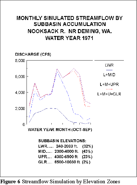
Figure 6. shows the relative monthly runoff simulated from individual (synthetic) sub-basins throughout water year 1971 for the Nooksack River at Deming, Washington. This basin was divided into four sub-basins (lower, middle, upper, and glacier). The great majority of winter discharge comes from the two lower sub-basins. The glacier sub-basin basically helps to hold up late summer streamflows.
Snow Modeling in Daily Operations
Once a model is calibrated, the NWS River Forecast Center runs the model on a daily basis, and some modifications (MODS) are made to adjust the model results to match observed streamflows more closely. But the snow story here is about the same as in the snow modeling for calibration: generally, no specific snow observations are input to update model results during the daily forecasting process.
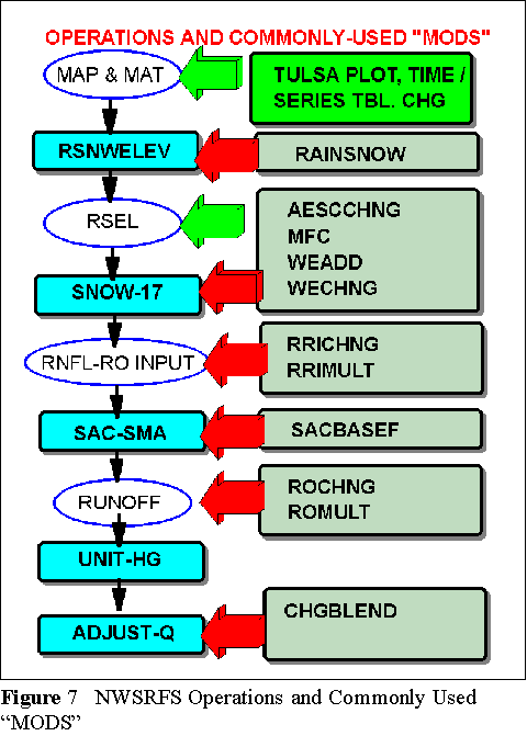
For each basin, the NWSRFS model is actually composed of an entire sequence of "operations", of which SNOW-17 and SAC-SMA are only two. Figure 7. shows a typical sequence of operations down the left side. Operations are in the rectangular boxes while the elements in ellipses represent a physical entity being modeled. The MODS and their points of application are shown on the right side of Figure 7. If the model is being used to accumulate snowcover for depletion in springtime water supply forecasting, the effect of daily MODS must be carefully considered in understanding the seasonal volume forecast obtained. Suppose, for example, that in order to fit an observed storm hydrograph through a particular three or four day period, the duty forecaster chooses to increase or decrease the Mean Areal Precipitation (MAP). This kind of MOD affects not only how the model fits observed discharge that particular day, but also profoundly affects the amount of snow being accumulated by the SNOW-17 model. It is the SNOW-17 operation that builds up basin snow water equivalent which will be depleted through the spring water supply period. In most cases, duty forecasters will choose NOT to modify the basic precipitation input, but rather choose to change the rainfall-runoff input (RRICHNG MOD), the SAC-SMA baseflow storage, or storages in other model "buckets". When this happens, the basic snow modeling is affected and spring season snowmelt results should be fairly true to calibration. Even the SAC-SMA MODS will, however, have some effect on seasonal volumes obtained.
Another concern for daily forecasting is how the process of data quality control is carried out. In order to have a truly objective tool for seasonal volume forecasting, precipitation and temperature data should be subject to quality control procedures that are objective, standardized, and repeatable by anyone who wishes to use the same model to reproduce the same volume forecast. In other words, subjective decision making should be kept to a minimum if the model is to produce objective results which are viable for interagency coordination of volume forecasts and river system operation.
In summary, development of standard operating procedures for daily forecast operations is very important. Seasonal volume forecasts obtained from the same model that is used in daily forecasting may have some essence of non-repeatability and non-objectivity. These issues must be addressed very carefully if the daily operational model is to perform dual service of (1) daily flow/flood forecasting and (2) being a truly viable seasonal forecast model as well. One possible alternative would be to run an "untouched" version of the model that is not modified daily to match observed flows.
Snow Modeling In Seasonal Volume Forecasting
Finally we come to the point where observations of snow are actually entered into the modeling system. This is by use of the Snow Estimation and Updating System (SEUS), which has been well documented by McManamon, et al. (1995). The simulated accumulation of snow water equivalent on a basin should be a very valuable tool in water supply forecasting. In fact, if data are prepared and processed in a sound objective way, it should conceptually be superior to any regression technique which uses only precipitation. It is important, however, is to take advantage of snow observations to update the model's knowledge of basin snow cover. This is what SEUS does.
The SEUS parameters are derived after the SNOW-17 and SAC-SMA models are calibrated for a basin. The SEUS calibration is accomplished by comparing observed and modeled (by SNOW-17) snow cover. Once the SEUS parameters are obtained, SEUS is run on the first of each month during the water supply forecast period to obtain an estimated snow water equivalent (SWE) for each sub-basin. The SNOW-17 SWE and the SEUS SWE are then compared and the SNOW-17 SWE is adjusted. This process is shown in Figure 8.
If SNOW-17 and SEUS SWE values differ, what is the "adjustment" procedure to come up with a new SNOW-17 SWE? At present, this is not well defined. One approach is simply to take the SEUS SWE as correct and use it to replace the SNOW-17 SWE. This would effectively throw away every precipitation measurement made in the basin during the month, which seems to be obviously undesirable. An optimal weighting system is in development which would allow an objective combination of the SNOW-17 and SEUS modeled SWE values. Table 2 shows some of the SNOW-17 and SEUS SWE values and corresponding 1996 seasonal water supply forecast for DWORSHAK Reservoir (Idaho) inflow. The adjustment shown were made on a subjective basis by the duty forecaster.
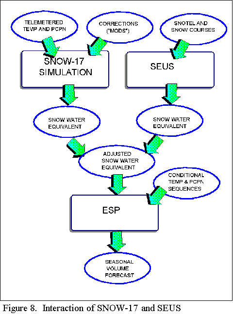
Table 2. NWSRFS/ESP Volume Forecast Comparison
         DWORSHAK Reservoir Inflow, Idaho, April-June 1996

          Basin Snow Water Equiv (in)    Forecast Volume (MAF)
DATE        NWSRFS        ADJUSTED       NWSRFS    STAT   FINAL

January 1
     LWR:      8.1     4.0     4.0
     UPR:     23.7    18.2    19.9         3.30    3.30     2.6

February
     LWR:      8.7     6.8     8.7
     UPR:     19.8    21.7    19.8         2.94    3.6      2.8

February 28 (Earlybird)
     LWR:     13.2     7.2     7.2
     UPR:     31.3     N/A    31.3         3.40

March 1
     LWR:     13.2     6.8     6.8
     UPR:     31.3    30.0    30.0         3.40    3.80     3.1

April 1
     LWR:      2.0     2.4     2.0
     UPR:     32.3    30.6    32.3         2.71    3.36     2.7
(1) The NWSRFS model should considerably improve the role of precipitation measurement in seasonal volume forecasting.
(2) The model should provide improved cognitive skill in extreme years, such as dry years of the very high baseflow winter of 1996 in the Idaho panhandle.
(3) Where does the Southern Oscillation Index (SOI) fit in? Properly, as an implicit predictor of future precipitation. The SOI is one of several indicators now being evaluated and used by the NWS Climate Analysis Center. The best approach is probably to condition future sequences of precipitation and temperature upon such indicators.
(4) Use of two parallel models may be investigated; one "touched" by duty forecasters in the process of daily operations, and one "untouched". One clear challenge is to learn how to "touch" the model to improve near-term forecast skill while improving long-term skill at the same time. If the model's conceptualization is reasonable, this should certainly be a realistic goal.
(5) SEUS provides important input of observed snow data. Personnel skills need development in use and evaluation of results.
(6) Objective means are under development to permit optimal objective weighting of SNOW-17 and SEUS snow water equivalent values for model updates. Such procedures are required to make the modeling approach fully viable for interagency coordination.
(7) Significant differences between historical, "daily operational", and "seasonal operational" precipitation need to be addressed to provide consistent and unbiased results for seasonal volume predictions.
(8) In mountainous areas of western Washington and western Oregon, there is a critical need for SEUS or SEUS-like procedures to incorporate snow depth and water equivalent measurements from low and mid-elevation stations to update snow water equivalents in lower elevation.
Reflections For The Future
(1) Improved model definition is needed to take advantage of the wealth of information available in modern GIS tools. The SEUS basin segmentation is a step in the right direction. Full consistency in basin segmentation between SEUS and the SNOW operation will probably give the best and most consistent result.
(2) The inclusion of snow information in the SNOW-17 model calibration itself is highly desirable, rather than having the only use of snow be in the SEUS update step. Iterative procedures between SEUS and SNOW-17 calibration should be investigated to assure improved "connectivity" between SEUS and SNOW-17.
References
Bissell, V.C., and C.E. Orwig, "Calibration of the NWS Model in the Northwest: A Status Report", Proceedings: 63rd Annual Western Snow Conference, pp. 135-138, Sparks, NV., April 1995.
Laurine, D.P., S. Hughes, M. Younger, and C.E. Orwig, "Applying the National Weather Service River Forecast System (NWSRFS) Interactive Forecast Program to Basins in Northwest Washington", Proceedings: 64rd Annual Western Snow Conference, (in press), Bend, Oregon, April, 1996.
McManamon, A., R.K. Hartman, and R. Hills, "Implementation of the Snow Estimation and Updating System (SEUS) in the Clearwater River Basin, Idaho", Proceedings: 63rd Annual Western Snow Conference, pp. 56-65, Sparks, NV., April 1995.
National Weather Service, "National Weather Service River Forecast System (NWSRFS)", NOAA Tech. Memo NWS-HYDRO-14, Dept. of Commerce, Silver, Spring, MD., 1972.
National Weather Service, Calibration Assistance Program, Dept. of Commerce, NOHRSC, Minneapolis, MN. 10pp., October, 1995.
1. Senior Hydrologist, National Weather Service, Northwest River Forecast Center, Portland, Oregon 97230
Presented at Western Snow Conference, Bend, Oregon, April, 1996