Inferenced Oceanic Kelvin/Rossby Wave Influence on
North American West Coast Precipitation
Martin E. Lee (1)
Dudley Chelton (2)
Abstract
The complex interaction of coupled ocean-atmosphere processes is still far from being completely understood, and documented. This work documents a nonclassic, oceanic Kelvin/Rossby wave conceptual model to partially explain above normal 1994-1996 precipitation patterns along the North American west coast. The proposed conceptual model focuses on an eastern Pacific post-El Niño heat transfer mechanism associated with oceanic Kelvin/Rossby waves that potentially affect preferential atmospheric forcing, resulting in selectively focused offshore storm track and moisture advection trajectories. Synergistic components of this model thereby have the potential to enhance (or reduce) U.S. west coast interannual precipitation. The magnitude of U.S. west coast flood damages incurred during the winters of 94/95 and 95/96 imply that analysis and assimilation of this proposed conceptual oceanic Kelvin/Rossby wave interaction may be worth considering in order to improve accuracy in forecast expectations for timing and placement of both above and below normal west coast annual and interannual precipitation. Other implications resulting from this research also include: 1) the imminent necessity of incorporating a multidisciplinary, combined earth systems approach in west coast precipitation forecasting; and 2) a concluding argument regarding the continued necessity for in situ oceanic observation programs beyond tropical latitudes.
Introduction
Accurate prediction of local precipitation is important for early flood warning and reservoir management, especially in mountainous areas of the western United States where severe flooding during heavy precipitation occurs in steep terrain and narrow valleys (Miller and Kim 1996). The National Weather Service (NWS), recognizing the economic and social value of accurate precipitation forecasts, dedicates significant resources to increase lead times of watches and warnings for flood and flash flood events (Olson et al. 1995). However, abrupt and vast data sparse upstream conditions commencing along a dominant land-sea boundary, marked by the west coast of the United States and the Pacific Ocean, introduce pronounced complexity to precise forecasting of significant precipitation. Upstream, air-sea interaction has the potential to modify both atmospheric temperature and wind fields that may then alter even global-scale atmospheric and oceanic circulations (Min wei and Dayong 1988). The ability to produce reliable forecasts in NWS Western Region locations of the United States is thus dependant on an appreciation and conceptual understanding of significant upstream ocean-atmosphere interactions.
During the winter of 1994-95, California received unusually large amounts of precipitation, with the Russian River Basin being among the hardest hit areas in January 1995, reporting over an estimated 800 million dollars in flood-related damages from just three consecutive strong storms between 7 and 11 January (Miller and Kim 1996). In the following winter (1995-96), western Oregon and Washington were inundated with numerous record-breaking winter floods. What substantive mechanism/s contributed to this sequence of interannual events? In general terms, variation in Pacific coast precipitation is the result of "annual variation in the interaction between the maritime westerlies from the North Pacific and the mountains of the U.S. West Coast" (Chen et al. 1996).
This paper considers hypothetical "nonclassic" (Hobbs et al. 1996) upstream ocean-atmosphere interactions responsible for producing excessive winter (1994-95, and 1995-96) west coast precipitation. Although not necessarily in the respective order given here, the dominant conceptual considerations in this analysis can be summarized by the following questions: 1) What are oceanic Rossby waves? 2) Did an interannual (1994-1996) heavy precipitation pattern shift northward along the west coast of the United States in association with a propagating oceanic Rossby wave associated with a pronounced but concluding El Niño event, trailing off with diminishing propagation speed at increasingly high latitudes? 3) What is the surface manifestation of oceanic Rossby waves as pertains to air-sea interaction that may affect precipitation? 4) Are SST anomalies associated with oceanic Rossby waves significant enough to alter preferred low-mid latitude moisture advection trajectories, localized atmospheric forcing, and resultant interannual west coast precipitation patterns? and 5) Is it cost-effective to even consider oceanic Rossby waves as a relevant factor in North American west coast operational forecasting? and 6) What are the short-long term implications if the answer to question number 5 is "yes"?
Significant 1994-1996 Trans-Pacific Ocean/Atmosphere Patterns
The Spring of 1995 was marked by below-normal equatorial eastern Pacific SSTs, and was followed by an active western Pacific Typhoon season in the Fall of 1995. This indicated that warm equatorial surface water had shifted west of the date line. The spring and summer of 1996 provided further confirmation of this in a disastrous manner. During this period Typhoons Ann, Frankie, Gloria, and Herb produced severe damage in Eastern Asia. For example, early-mid July 1996 severe, typhoon related weather and flooding in southern-central China was responsible for 1,108 deaths, and an estimated $11.23 billion in economic losses across Anhui, Guangxi, Guizhou, Hubei, Hunan, Jiangsu, Jiangxi, and Zhejiang provinces. In these provinces flooding was responsible for damage to 2.8 million homes and the collapse of another 810,000 homes, leaving millions of people homeless, and also destroying over 5 million tons of grain (Reuters Limited, Beijing: July 25, 1996). Before moving into Eastern China, Typhoon Gloria was responsible for an estimated 50 deaths in the Philippines (Philippine News Agency, Manila: July 29, 1996), and $21 million in crop damages across southern Taiwan (Reuters Limited, Hong Kong: August 2, 1996). Typhoon Herb then caused another 39 deaths in the Philippines (Reuters Limited, Manila: July 29, 1996), also before clipping Taiwan and moving into Eastern China.
Remnant decaying tropical storms advecting to higher latitudes then resulted in 68 deaths and $246 million in flood damage across South Korea (Reuters Limited, Seoul: July 31, 1996). This included the loss of an estimated four tons of ammunition (hand grenades, mortar and artillery shells, and land mines) swept away by flood waters. Another estimated 860 tons of ammunition stored near the North Korean Border was buried by flood induced landslides. During this stormy season in the western Pacific, Typhoon Bart typified a fully recurving storm (Fig. 1), with its decaying remnants entraining into a trans-Pacific westerly jet stream, eventually resulting in U.S. west coast precipitation interception during May 1996. However, this U.S. west coast precipitation was minor in significance when compared to cumulative U.S. west coast winter 1994-95 and 1995-96 precipitation.
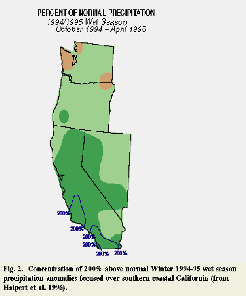
Halpert et al. (1996) note that abnormally high 1994-95 winter season precipitation was observed in California and the southwestern United States. This pattern, especially from December 1994 to February 1995, was associated with an eastward extension of a jet stream core across the Pacific and into California. During January 1995, the jet stream core and storm track aimed at California was displaced 18 of latitude south of their typical location. Resulting significantly above-normal precipitation steered into California at that time, producing excessive flooding throughout the state. During January 1995, the southern Cascades, the northern Sierra Nevada, and several central-coastal California locations observed 950-1050 mm of precipitation, and October-April totals in parts of southern California reached at least two times the normal seasonal total records (Fig. 2). According to the Products and Services Division of the National Climate Data Center, over 3.0 billion dollars in flood damage was assessed from January-March 1995 flooding in California - including 27 deaths.
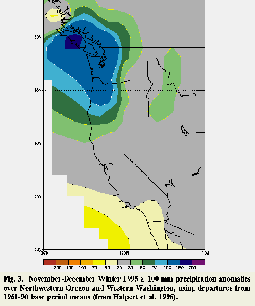
In the following winter (1995-96), severe river flooding (especially west of the Cascades) occurred in western Washington and northwestern Oregon, where 200-500 mm of heavy rain fell from November-December 1995 (see Fig. 3). Enhanced warm, moist, southwesterly flow facilitated this excessive precipitation pattern anomaly. As noted above, March-May 1995 marked the end of El Niño/ Southern Oscillation (ENSO) conditions across the Pacific. For example, below normal SSTs developed from the South American coast and the equatorial Pacific to 120W, where SSTs reached -1.0C in many areas (see Fig. 4). Central Pacific maximum positive SST anomalies had significantly diminished, and central equatorial Pacific atmospheric convection returned to normal. Near normal low-level equatorial easterlies also reappeared, and western Pacific SST anomalies exceeded 0.5C above normal between 120E to 150E.
El Niño processes, by classic definition, were therefore relinquishing control of weather patterns over the eastern Pacific. Yet, according to the Products and Services Division of the National Climate Data Center, February 1996 Oregon uninsured flood damage alone reached 400 million dollars. Over 300 million dollars damage to Oregon highways and waterway infrastructures was also reported. Overall flood damage to the Pacific Northwest is now estimated to approach $1 billion - including 14 fatalities. Thus, one of the driving question becomes: "What other mechanisms have we learned enough about to explain this above normal, non El Niño winter precipitation pattern over western North America?"
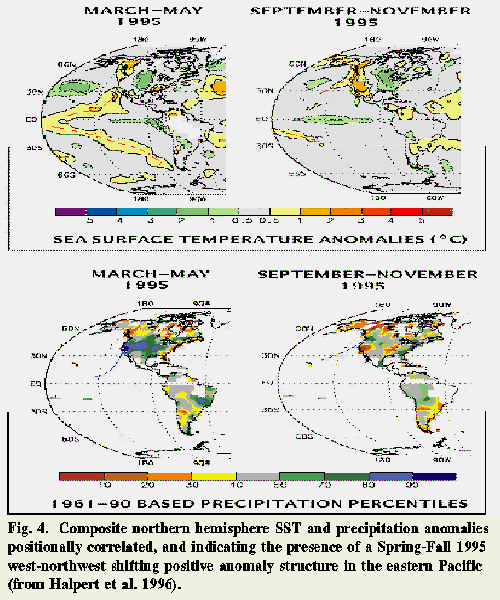
Surprising structure and symmetry in eastern Pacific March-May 1996 positive SST anomalies (see Fig. 4) provide potential clues to answering the previously raised question. For example, a coupled, northern and southern hemisphere, poleward "banana-shaped" positive SST anomaly structure is evident over the eastern Pacific in Fig. 4, symmetric the equator. Subsidiary clues are derived from an apparent northwestward shift of eastern Pacific positive SST anomalies along the U.S. west coast, from March-May 1995 to September-November 1995. This northern hemisphere, northwestward SST positive anomaly shift is puzzling in the context of first order eastern Pacific semi permanent atmospheric and ocean current circulation patterns. For example, clockwise circulation around semi permanent eastern Pacific high pressure results in mean equatorward surface wind components along the southwestern U.S. coast. Similarly, eastern Pacific mean ocean currents along the western U.S. coast are characterized by equatorward flow (see Fig. 5).
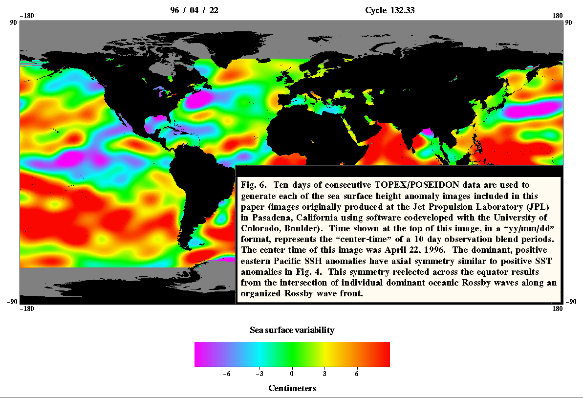
A direct correlation exists between the organized eastern Pacific positive SST anomaly behavior described above and positive Sea Surface Height (SSH) anomaly structure (see Fig. 6). Additionally, this 1995-1996 ocean system phenomenon has symmetry matching strong November 1995 and February 1996 storm tracks - routed from near the Hawaiian Islands, along northward curving subtropical jet streams, often referred to as a "Pineapple Express." These associations eventually resulted in the formulation of a conceptual model that can explain the previously discussed northwestward shift of SST anomalies. The positive, symmetric SSH anomaly structure in Fig. 6 correspond to positive SST anomalies (Bob Cheney 1996, personal communication) via a selective redistribution of heat energy (Dudley Chelton 1997, personal communication). Both the positive SST and SSH offshore anomalies are associated with oceanic Rossby waves. In the following sections, this association is developed into a conceptual model that can be used to inferentially explain how and why oceanic Kelvin and Rossby waves may be linked directly to: 1) poleward shifts of eastern Pacific positive SST anomalies; and 2) selectively focused precipitation patterns along the U.S. west coast. Concluding sections of this text also explore the plausibility and ramifications of this proposed model, as well as subsidiary planning, design, and management issues.
Oceanic Rossby Wave Observations and Theory
Technological advancement in observation sampling capabilities has made it possible to improve our understanding of ocean circulations that play critical roles in varying climate over a wide range of time scales: from seasonal to interannual (e.g., El Niño phenomenon) to decades and even centuries - as revealed in recent ice core analyses (Johnson et al. 1992). Our ability to identify ever smaller scale ocean circulation processes is also increasing. For example, the decline in intensity of the eastward flowing Kuroshio Extension and its westward recirculation gyre has been linked to energy transfers from the mean current flow to an eddy field in a region south of the Kuroshio Extension (Qiu 1995). In the quest to further understand these increasingly evident complex ocean system processes, remote sensing has become the most practical approach to observe seasonal-to-interannual ocean variability on global scales with adequate space and time resolution; and recent advancements in satellite observing systems have significantly improved our ability to monitor global ocean circulation.
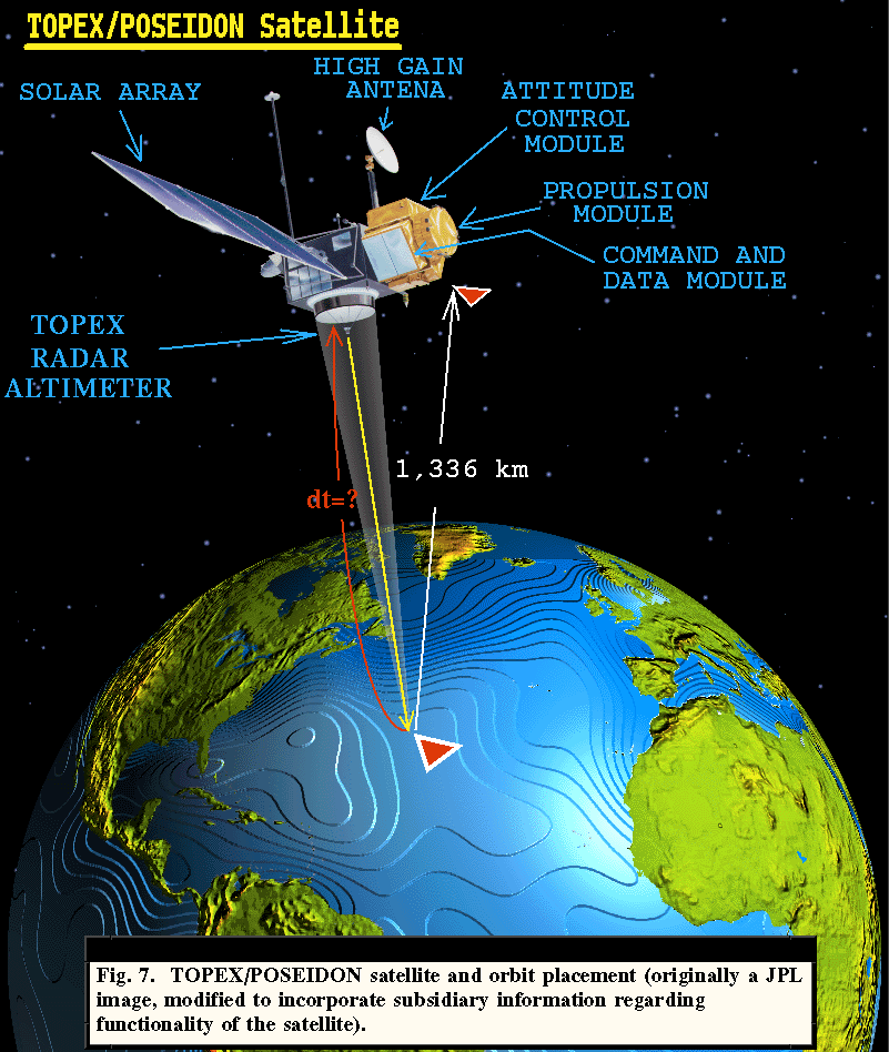
A precision radar altimeter aboard the TOPEX/ POSEIDON satellite provides the most accurate, currently available altimeter data for studying general ocean circulation and its variability (Fu et al. 1994; Fu and Cheney 1996). This is possible using altimetric measurement of sea surface elevation, because low-frequency sea level variations (i.e., with tidal variation removed) are indicative of motions throughout much of the water column - extending to the sea floor in certain instances (Pedlosky 1979). TOPEX is the U.S. acronym for Ocean Topography Experiment, a joint mission with France. POSEIDON, the mythical Greek god of the sea, is the acronym for the French contribution to this mission. The TOPEX/POSEIDON satellite is a modified Multimission Modular Spacecraft configured with the first spaceborne dual-frequency (5.3 and 13.6 GHz) radar altimeter. The radar altimeter was designed and constructed by the Applied Physics Laboratory of the Johns Hopkins University (APL/JHU), and the 2,500 kg satellite was launched into a highly stable orbit on August 10, 1992, by an Ariane 42P rocket from the European Space Agency's Guiana Space Center in French Guiana (Fu et al. 1994). The launch vehicle was contributed to this project by the "Centre National d'Etudes Spatiales (CNES)," or the National Center of Space Studies, France's equivalent of NASA.
The TOPEX/POSEIDON satellite has a 66 inclination orbit 1,336 km above the earth's surface (see Fig. 7). Sea surface height is observed by a TOPEX radar signal reflected off the ocean's surface. The dual-frequency altimeter allows for a correction for ionospheric effects on the 2-way travel time of radar pulses. The time calculated for a standard local sea level radar return is compared to the measured return time. If the return signal takes less time, the ocean surface is above its standard reference sea level. Insertion into orbit was so successful that sufficient fuel remains aboard the satellite to sustain its mission significantly beyond the year 2000.
Satellite altimetry, provided via projects like the TOPEX/POSEIDON mission, is probably the only way that global oceanic circulations can be studied relative to the sea surface as a reference level, because the geostrophic surface velocity can be determined from the satellite derived surface height (Fu and Smith 1996). Ocean surface currents are initially forced by momentum transfer from the atmosphere. Yet, once free from direct forcing by the wind, these nearly geostrophic currents tend to move slowly and nearly frictionlessly under pressure gradient and Coriolis force influences. Thus, sea surface height anomaly data across these currents facilitates theoretical current velocity estimations. A positive 1 cm sea surface height change may generate an elevated slab containing the equivalent of several millions of cubic meters of water per second, a rate of discharge greater than all the rivers in the world (from the JPL TOPEX/ POSEIDON Mission HomePage, http//topex-www.jpl.nasa.gov/). Although lesser in scope, significant responses also occur at smaller than global-hemispheric scales, where other quasigeostrophic processes are at work. Oceanic Rossby waves fall within this category. The theoretical oceanic Rossby wave length scale LI ( the Rossby deformation radius) is equal to the product of a characteristic buoyancy frequency and its vertical scale divided by the Coriolis parameter. At 30 latitude, LI 70 km, compared to the analogous atmospheric Rossby length scale, LA 1900 km. Conversely, the time scale for LI 60 days, while the time scale for LA 2 days (Stewart 1985). Local vertical, latitudinal variation of the Earth's angular rotation vector - resulting from curvature of the Earth's surface - provides the restoring force for oceanic Rossby waves (Pedlosky 1979). These waves are considered to play a key role in modern large-scale ocean circulation theory. They are also considered an important mechanism in the westward intensification of large-scale circulation gyres (Anderson and Gill 1975; Anderson et al. 1979).
Wind and thermal buoyancy forcing, at eastern ocean boundaries and interior regions, generate oceanic Rossby waves; and El Niño events are also oceanic Rossby wave generators (Barnett et al. 1991; Neelin et al. 1994; Battisti and Sarachik 1995). Eastward propagating oceanic equatorial Kelvin waves, forced in the western Pacific by wind anomalies associated with El Niño events, generate poleward propagating coastally trapped Kelvin waves when they reach the eastern boundary of the Pacific, resulting in positive sea surface height anomalies that have been observed to propagate as far north as the Gulf of Alaska. These forced, positive sea surface height anomalies generate westward propagating oceanic Rossby waves along the west coast of the Americas. Model results suggest that these westward propagating waves may extend well into high latitudes, covering the entire North Pacific, remaining largely undamped to 160 W longitude, and continuing into the western Pacific a decade later (Jacobs et al. 1994). Jacobs et al. (1994) also note that El Niño generated oceanic Rossby waves may be linked with North Pacific mid latitude ocean circulation anomalies a decade later. They have hypothesized that these transient ocean circulations may have a non-trivial impact on North American weather patterns. The simplistic theoretical impact these Rossby waves have on eastern Pacific Meteorology is that they appear to facilitate a complex exchange process. The 1-10 cm sea surface height signatures of oceanic Rossby waves are associated with much greater thermocline depth variations ( 3 orders of magnitude, and opposite in sign). Thus, oceanic Rossby wave signals represent large thermal variations in the upper ocean.
Initially, oceanic Rossby waves provide transient ocean circulation adjustment in response to large-scale atmospheric forcing. The resulting anomalous change in ocean circulation may then be capable of influencing climate. Despite their importance in time varying oceanic processes, Rossby wave surface signatures are difficult to detect, with height variations of less than 10 cm over wavelengths ranging from hundreds to thousands of kilometers. However, the TOPEX/ POSEIDON altimeter is capable of continuous measurement accuracy of 3 cm since becoming fully operational in October 1992, and amplitudes as small as 1 cm can be detected in large-scale sea level signals over the entire world ocean, after measurement error filtering is performed. The TOPEX/POSEIDON altimeter is thus able to detect oceanic Rossby waves unambiguously (Schlax and Chelton 1994; Parke et al. 1987; Fu et al. 1994). The remainder of this paper examines the associative correlations of these oceanic Rossby waves, via their sea surface height and sea surface temperature (SST) anomalies, with potential 1994-1996 eastern Pacific and western North American weather modification.
Tropical Air-Sea Interaction
Bocheng and Qiyu (1988) remark that "the western tropical Pacific ocean is the largest heat and moisture source on the earth...." As a result, it has a significant impact on Asian, as well as world climate. Variations in western tropical Pacific current systems are intimately linked to El Niño events. This air-sea interaction is the subject of intensive research that has resulted in our increased appreciation of how both oceanic and atmospheric responses are inextricably dependent upon forcings and exchanges between these two complicated systems. For example, Hendon and Salby (1996) note that atmospheric frictional wave-CISK (conditional instability of the second kind) explains eastward frequency selections in western Pacific tropical to subtropical atmospheric circulation and anomalous convection interactions. In the western Pacific this interaction is highly correlated with equatorial frictional convergence that shifts towards warm SST anomalies, and is associated with dynamical responses involving forced Kelvin and Rossby wave disturbances. Shifting toward positive temperature anomalies results in a net tropical eddy available potential energy gain that facilitates amplification of eastward convective components, and the frequency of these eastward components is dominated by unstable tropical Kelvin wave structure in the atmosphere. However, frictional wave-CISK correlations (assuming a zonal SST variation) become insignificant in the eastern Pacific - because typically colder SSTs do not provide sufficient climatological convection. This distinction of eastern Pacific tropical-subtropical atmospheric processes, different from those in the western Pacific, is another manifestation of how important it is to understand air-sea interactions over the Pacific.
Tropical Pacific ocean SSTs are relatively uniform, in that cold, dense water characteristically lies below a thin, wind-mixed layer ( 100 m thick) of much warmer water. The highly stratified region separating the weakly stratified shallow and deep layer is called the thermocline (Stewart 1985). However, at the onset of the 1986-1988 El Niño / Southern Oscillation (ENSO) episode, anomalous eastward transport of warm surface mixed layer water was observed equatorward of 10 N latitude. In response to the eastward export of surface mixed layer water away from the western Pacific, the thermocline in the tropical western Pacific essentially "shoaled," coinciding with observed decreases in dynamic height over the upper (300-400 m) tropical western Pacific ocean (Toole et al. 1988). Eastward export of warm surface layer water also resulted in colder temperatures observed over the surface of the tropical western Pacific ocean.
According to Chan and Lau (1988), SSTs are one of the most significant factors in the generation and maintenance of tropical convective cloud processes. These convective processes have been correlated with selective variance around tropical SSTs of 28C, and outgoing longwave radiation values of 240 Wm-2. The SST relationships between a convectively active, relatively warm western Pacific versus a convectively suppressed, relatively cooler eastern Pacific may vary by only a few degrees C. Hansen (1988) categorized 1C anomalies observed during 1986 in the Pacific as "large." Various moist process cycles, resulting in eastward propagation of convection toward the eastern Pacific (including El Niño/Southern Oscillation (ENSO) events) may be attributed to these smaller warm SST anomalies through their enhancement of unstable conditions conducive to sustained atmospheric convection (Chan and Lau 1988).
This unstable air-sea interaction is largely driven by turbulent flux exchange across the ocean-atmosphere interface, transforming SST anomalies into diabatic heating that results in forcing of the free atmosphere (Min wei and Dayong 1988). In the tropics, significant positive and/or negative SST anomalies can also be frequently correlated with observed changes in atmospheric boundary layer wind regimes (Dayong et al. 1988). In the tropical eastward on-set of an El Niño event, positive SST anomalies directly result in surface wind convergence and associated precipitation fields (Barnett et al. 1991). Barnett et al. (1991) caveat that the direct effect of heat exchange from the ocean to the atmosphere is relatively weak in forcing of the main troposphere. However, the air-sea temperature difference has a very important indirect role in the thermodynamics of atmospheric circulation: the low-level surface wind convergence associated with the positive SST forcing provides critical initiation of vertical mass and water vapor flux above the planetary boundary layer (PBL), thus determining where heat from condensation in the troposphere occurs. This tropospheric heat of condensation is estimated to be four times greater than sensible heat flux from the ocean into the lower PBL, but its positioning is tied to the positive SST anomaly feedback.
Selective subtropical to global scale temperature modifications result at the hemispheric scale from Hadley circulation of net poleward energy flux, and the Hadley circulation of this energy flux is largely forced by the addition of low latitude surface latent heating (Palmén and Newton 1969; Min wei and Dayong 1988). On the scale of tropical Kelvin wave processes in the eastern Pacific, Hendon and Salby (1996) conclude that convective disturbances "can be understood as the propagating response to transient heating that is localized." Using numerical simulations, Wendell (1988) also found that even mid-latitude SST warming significantly impacted cyclogenisis in boundary layer interaction with cyclones, via increasing planetary boundary layer (PBL) "convergence and redistribution of surface heat to the midtroposphere�." Jacobs et al. (1994) have observed high-latitude SST anomalies across the North Pacific of the same magnitude and temporal-spatial extent as those in equatorial latitudes during El Niño events. Despite relatively minor magnitudes of positive SST anomalies (ie., compared to magnitudes of typical frontal inversions in the atmosphere), the microscale effects of converging low level moist air also contribute to further destabilizing of the PBL (Stull 1988). Collectively, these low-mid latitude dynamic processes thus have the potential to re-define higher latitude storm tracks, primarily as a result of mean zonal temperature field modification (Lee and Mak 1996).
Proposed Ocean-Atmosphere Conceptual Model
Fig. 6 is a global map of sea level constructed from TOPEX/ POSEIDON altimeter data acquired in April 1996. The positive Sea Surface Height (SSH) anomalies of 3 cm over the eastern Pacific, in both the northern and southern hemispheres, have a structure consistent with that expected for an oceanic Rossby wave crest: the positive SSH anomaly gradually curves from mid-high latitude far eastern Pacific coastal boundaries towards Western Pacific tropical latitudes. Positive SST anomalies in Fig. 4 have similar structure to that of the positive SSH anomalies in Fig. 6. These two positive anomaly structures are directly associated, and the mechanism responsible for this correlated structure is the latitudinal variation of oceanic Rossby waves initiated nearly simultaneously along the eastern boundary of the Pacific (Chelton and Schlax 1996). These latitudinally dependent oceanic Rossby waves are thought to be initiated by passage of coastally trapped, poleward propagating baroclinic oceanic Kelvin waves. Oceanic Kelvin waves have been observed in current meter and hydrographic data along the west coast of South America (Smith 1978; Huyer 1980), and Dorman (1985) has presented evidence of trapped, internal oceanic Kelvin wave existence along the coast of California.
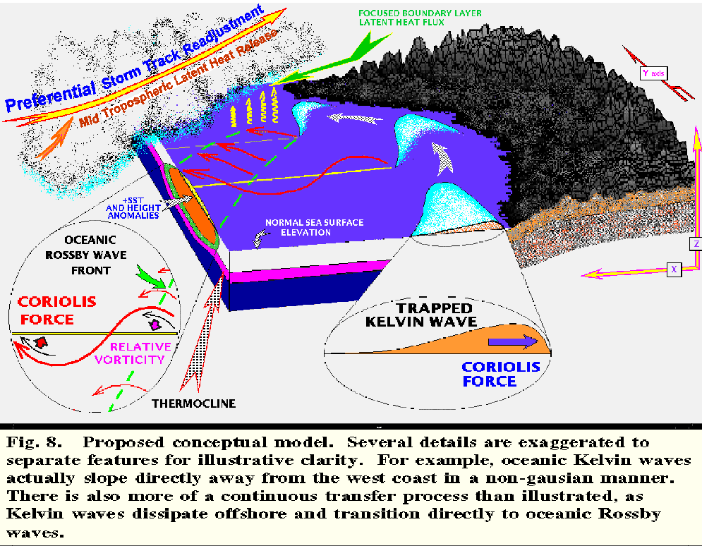
Coastally trapped, oceanic Kelvin waves, propagating poleward along the west coasts of North and South America, are balanced directly along the coast by pressure gradient and Coriolis forces (Dorman 1985). Allowing poleward propagating, trapped oceanic Kelvin waves originating off Central America to reach the Gulf of Alaska, this relatively undamped ageostrophic force balance is directly analogous to trapped barrier jets in the atmosphere. Trapped oceanic Kelvin waves decay exponentially offshore over a length scale equivalent to the Rossby radius of deformation. The initiation of a westward propagating oceanic Rossby wave by a trapped, poleward propagating oceanic Kelvin wave is illustrated in Fig. 8. Because of the "-effect" of latitudinal variation of the Coriolis parameter, SSH anomalies associated with coastal Kelvin waves propagate westward as oceanic Rossby waves. As time elapses and trapped, oceanic Kelvin waves continue to propagate poleward and oceanic Rossby waves are initiated at increasingly higher latitudes.
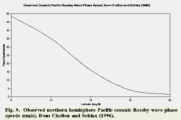
The phase delay in the initiation of oceanic Rossby waves at higher latitudes contributes to the increasing lag of more poleward Rossby wave initiation. Also, the phase speed of oceanic Rossby waves decreases rapidly with increasing latitude at mid-latitudes (see Fig. 9). These two factors result in wave crests and troughs that are approximately symmetric about the equator, as previously discussed in terms of the positive SST and SSH anomaly symmetry in Figs. 4 and 6. The associations presented in the previous section suggest the potential atmospheric forcing effects that this oceanic Rossby wave crest-front may have on eastern Pacific organized precipitation processes. In summary, this ocean-atmosphere interaction is linked by geographically focused boundary layer latent heat flux that is selectively forced by the structured, positive SST patterns associated with oceanic Rossby waves. Could this selective enhancement of upstream precipitation along preferential storm tracks have resulted in heavy, post El Niño west coast precipitation (see Figs. 2-3, 8, and 10)?
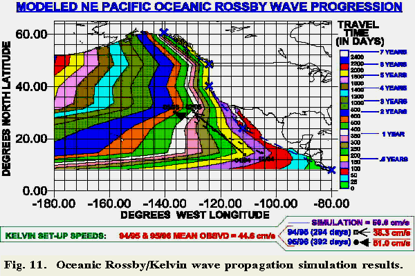
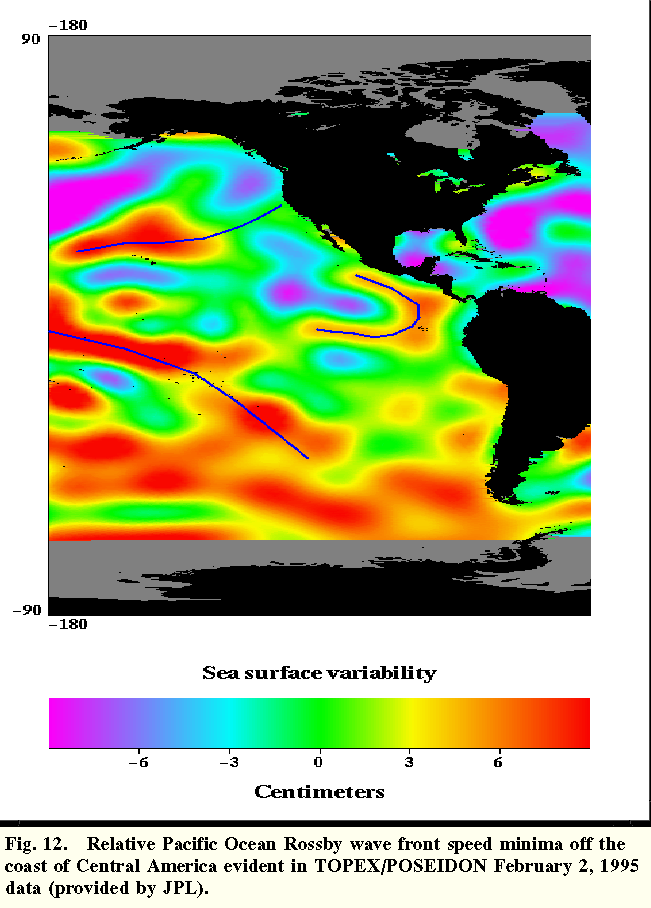
A simple simulation of trapped oceanic Kelvin and Rossby wave propagation along the North American west coast was developed to further study the plausibility of this conceptual model. A constant phase speed of 50 cm/s was used for poleward propagating trapped, oceanic coastal Kelvin waves propagating poleward along the west coast of Central and North America. Observed Pacific oceanic Rossby wave phase speeds, from Chelton and Schlax (1996), were selected for use in this simulation (see Fig. 9). Results from this simulation, using these component oceanic Kelvin and Rossby wave properties, are illustrated in Fig. 11. These simulation results reveal critical details regarding the organized oceanic Rossby wave crests observed in nature. For example, a localized minimum in the westward propagation distance (between 15N, 102-121W) clearly appears between 100-250 days after Kelvin waves propagate poleward of 8 N latitude. This is primarily a result of the orientation of the Central American coastline. This coastal effect results in Rossby waves at higher latitude later time-steps to actually exceed the westward longitudinal position achieved by previously initiated lower latitude Rossby waves. This simulation result is extremely useful in explaining TOPEX/POSEIDON positive SSH anomaly patterns off the west coast of Central America in Fig. 12.
Oceanic Rossby wave crests identified in TOPEX/POSEIDON data, between April 1994-February 1995 and December 1994-May 1996, were tracked from 14N to 30N (see Fig. 11). These two dominant wave crests coincided in time, respectively, with the abnormally wet 1994-1996 winter seasons experienced in the Western U.S. The mean, estimated oceanic Kelvin wave phase speeds for the 94/95 winter case was 38.3 cm/s (over a 294 day period), while for the 95/96 winter case, it was estimated to be 51.0 cm/s (over a 392 day period). The combined, mean oceanic Kelvin phase speed for both cases was 44.6 cm/s (within 12% of the assumed Kelvin phase speed of 50 cm/s, selected for use in the Fig. 11 simulation result). The estimated phase speed differences may possibly be attributed to a change of the initial phasing of the two analyzed oceanic Kelvin/Rossby wave events (an 13 cm/s difference in 1994-1996 freely propagating oceanic Kelvin wave phase speed would require substantial changes in ocean density structure). Regardless of the specific reason for the differences, this raises critical questions concerning the seasonal positioning of dominant oceanic Rossby wave crests.
Did more southeastward positioning of estimated 94/95 winter season dominant oceanic Rossby wave front (the 350-400 day Rossby crest solution in Fig. 11) result in selective aiming of more preferential, heavy precipitation storm tracks into southern California? Similarly, in the following 95/96 winter season, did a more northwestward positioned dominant oceanic Rossby wave crest (the 500-600 day Rossby crest solution in Fig. 11) provide sufficient forcing to result in more westward positioned, transient "pineapple express" storm tracks to intersect the North American west coast further north, toward Oregon and Washington (see Figs. 2-3, and 8)? A multitude of other questions remains regarding these simulation results, in conjunction with our increasing empirical knowledge of ocean science via observational data from sources such as the TOPEX/POSEIDON project. For example, if the conceptual model proposed here is realized in nature, what are the implications regarding precipitation/storm track re-adjustment 2-6 years following the demise of a significant El Niño event in the eastern Pacific (for example, in the 800-2400 day Rossby crest solutions in Fig. 11)? Without the oceanic Kelvin-Rossby wave conceptual model component described above (Figs. 8 and 11), it is difficult to make concise analytic inferences regarding the origins of observed sea surface anomaly patterns, and potentially our west coast heavy winter precipitation patterns, too.
Conclusion
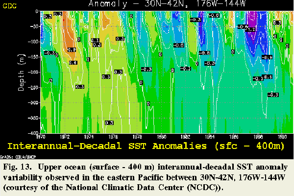
Our understanding of large to local scale coupled ocean-atmosphere processes is far from complete, but knowledge is accumulating, for example, from studies such as those conducted by the Climate Diagnostic Center to examine the role of air-sea interactions in climate and climate change. Results from one of these studies illustrate the significant upper level ocean (surface to 400 m) thermal structure interannual to decadal variability that is known to occur in the central North Pacific (Fig. 13). Westward propagating oceanic Rossby waves, capable of significantly altering thermal properties in this slab of surface layer water, have now been observed throughout much of the world's oceans (Schlax and Chelton 1994). The slow propagation speeds of mid-latitude oceanic Rossby waves, in conjunction with associated SST anomalies, and previously discussed inferences concerning possible resultant atmospheric responses, suggest that a significant, and difficult to forecast relationship between oceanic Kelvin/Rossby waves and North American west coast weather patterns may exist. This relationship may be a critical component leading to unusual interannual west coast weather patterns. However, the results of this analysis are not conclusive, and do not constitute absolute proof of the hypothesized links between oceanic Rossby waves and atmospheric processes.
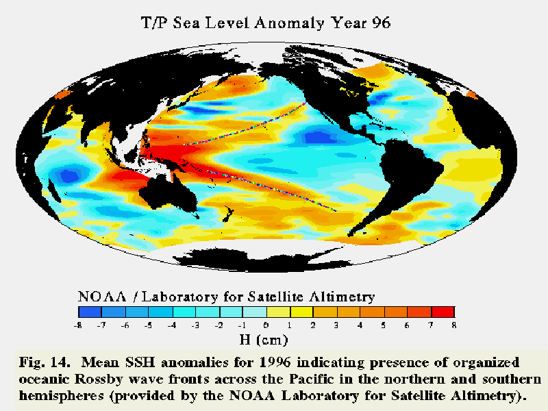
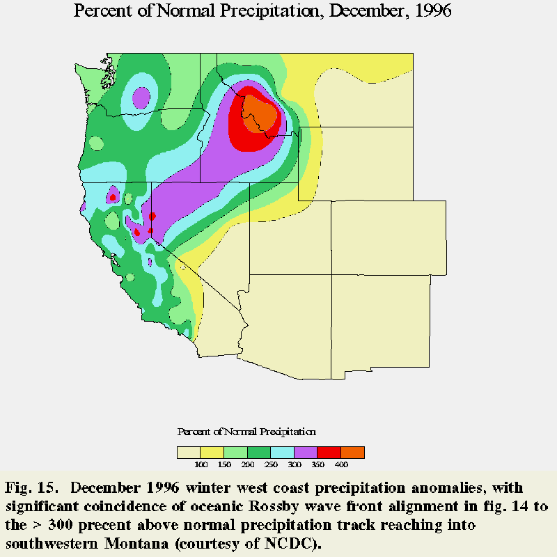
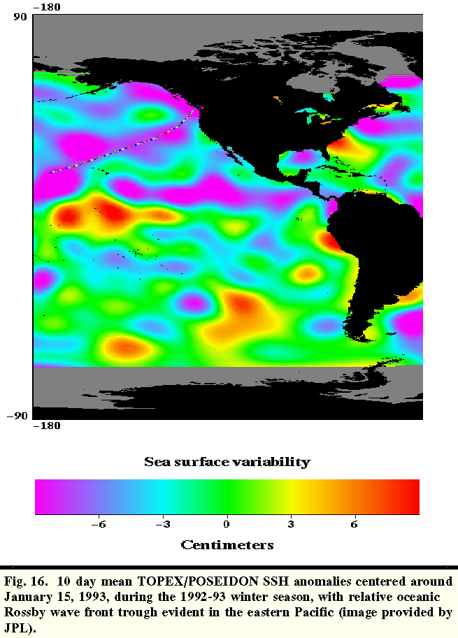
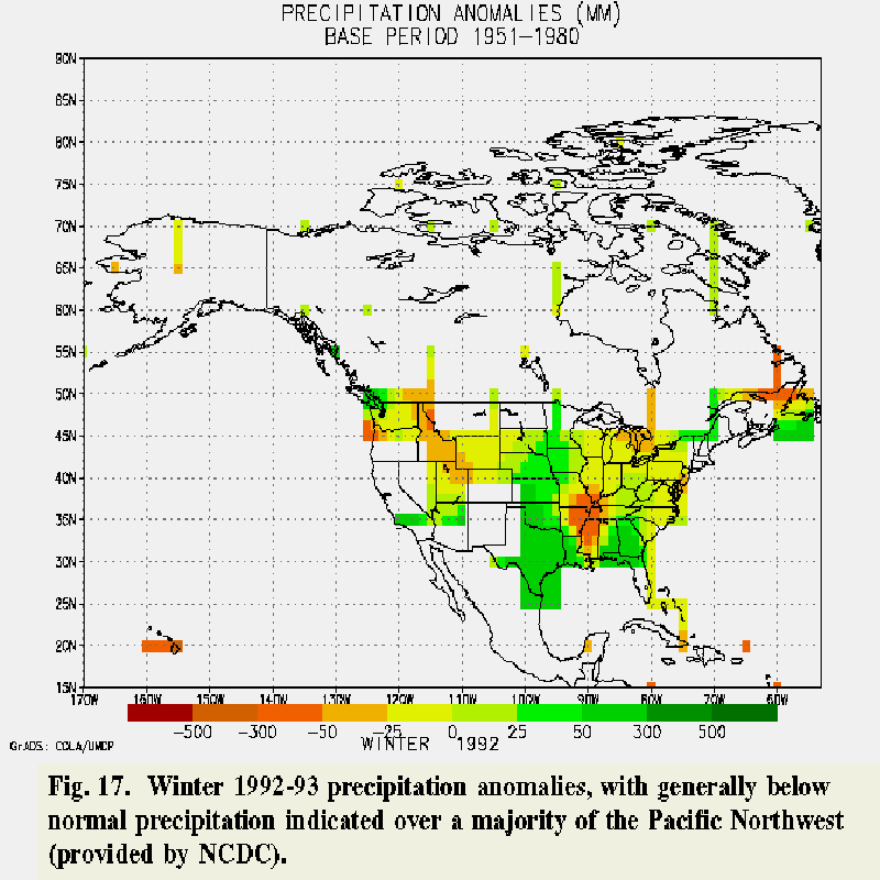
From preliminary inspection, oceanic Rossby wave forcing of the atmosphere appears unable to produce continuous storm track modification, either intraseasonally (time scales of 10-100 days) or interannually. Other dominant, larger scale synoptic-hemispheric scale processes often diminish the signal level of oceanic Rossby wave forcing (Trenberth 1997). However, if the associative links suggested in this paper (ie., significant, positive SST anomalies with geographical patterns organized by oceanic Kelvin/Rossby wave processes - intersecting upstream trans-Pacific jet stream tracks) reach a critical feedback threshold, then it may be possible to make the following inferences. Meridionally skewed crests and troughs of dominant warm core, eastern Pacific oceanic Rossby waves near the west coast of the United States, particularly following El Niño events transitioning into La Niña episodes, may be highly correlated with the geographical distribution and intensity of above normal, west coast winter precipitation (see Fig. 8). Thus, recognition of this ocean system process, occasionally resulting in transient resonant, phase-locking with atmospheric processes, may significantly improve medium-long range forecasting accuracy of heavy seasonal west coast precipitation interception. For example, the mean 1996 Pacific SSH anomaly pattern (Fig. 14) has evident correlation with placement of significantly above normal December 1996 precipitation (Fig. 15). Conversely, drought forecasts for the west coast may also be improved - by anticipating the development of prolonged high pressure ridging over Washington, Oregon, and California. This drought scenario may result as the SST patterns associated with oceanic Rosby waves steer above-normal precipitation into British Columbia and Alaska (refer to Fig. 11 wave crest and trough locations after 800 days). Or, perhaps west coast scenarios suggestive of below-normal precipitation may also be correlated with cold SST patterns associated with oceanic Rossby wave troughs (Fig. 16). For example, Fig. 17 places below-normal precipitation over Washington and northern Oregon, aligned along the upstream orientation of a dominant oceanic Rossby wave trough in Fig. 16.
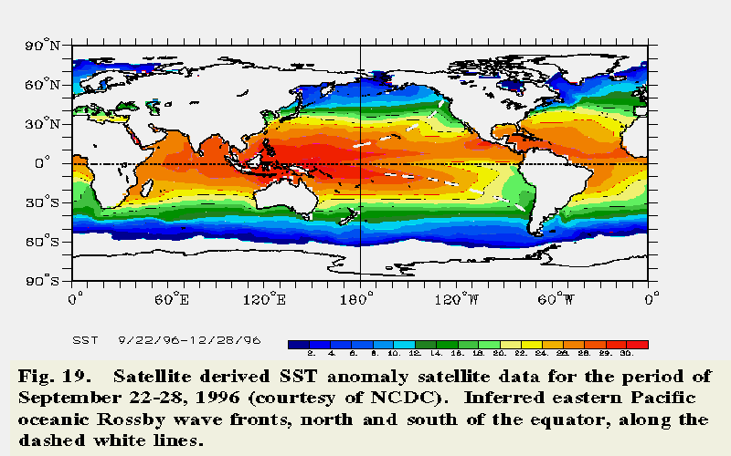
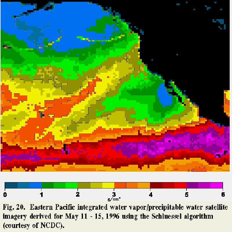
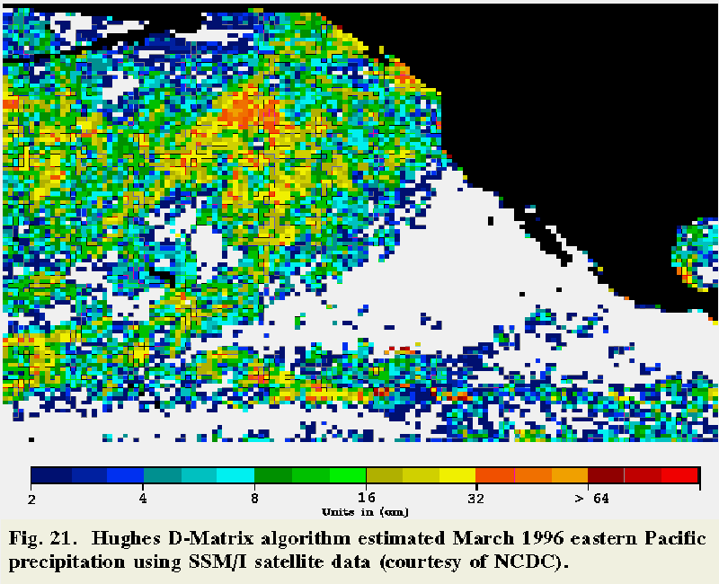
Regarding the consideration of oceanic Rossby waves in west coast drought forecasting, mid Pacific model results imply oceanic Rossby waves of low-latitude origin in association with El Niño events influence the location of the Kuroshio Extension between 35-40 N (Jacobs et al. 1994). However, the role of larger scale ocean-atmosphere processes - such as the eastward extension of a warm northerly Kuroshio return current - may be more important to North American west coast forecasting. The cumulative potential west coast meteorological and hydrologic scenario results postulated in the previous paragraph nonetheless suggest that consideration of pronounced eastern Pacific oceanic Rossby wave activity may be warranted. Organized oceanic Rossby wave thermal forcing of the atmosphere appears to be more of a microscale influence, but over a sufficiently large and consistent subregion. Repetitive tracking of storms following northward along the eastern U.S. are often linked to the baroclinic zone established along the coast, defined by contrasting cold continental air over run by warmer, moist marine air masses advected over the Gulf Stream (Carlson 1991). Although not energetically capable of producing similar extreme contrasts, eastern Pacific oceanic Rossby waves may be instrumental in establishing a much weaker yet still analogous baroclinic atmospheric tracking zone. Using this conceptual model, forecasters may be more able to make large-scale process inferences in sparse and/or remote data sets (see Figs. 18, 19, 20, and 21). What other existing, coupled conceptual models do forecasters presently use to explain the patterns in Figs. 14, 15, 16, and 17? Keeping in mind the billions of dollars in west coast flood damage between 1994-1996, it seems prudent to consider the potential association/s proposed in the multifaceted conceptual model introduced above?
If this conceptual model is considered a potential mechanism to partially explain variations in heavy west coast precipitation patterns, how do we systematically make the necessary associations suggested in this paper? Slow oceanic Rossby wave propagation speeds (on the order of 10 cm/s) facilitate interrupted analysis and tracking, for example, when other operations take prolonged precedence, and/or relevant analysis data availability is temporarily limited. Observing the presence of dominant oceanic Rossby waves may entail a consistent, periodic analysis of remotely sensed eastern Pacific SST and SSH anomalies, in conjunction with possibly correlated DMSP microwave precipitation and preferential GOESS-9 water vapor moisture advection tracks from low to mid latitudes. Drifting buoy data is another source of supplementary, in situ SST anomaly observations to correlate with SSH data.
This integrated approach is probably the only presently available operational technique to use in conceptually identifying the potential occurrence of pronounced oceanic Rossby wave activity at the field office level. Because of oceanic Rossby wave process subtleties, development of a working conceptual model that incorporates key evolution and structure details will be necessary before predictive skills can be evolved (McGinley 1986).
TOPEX/POSEIDON altimeter data capable of resolving oceanic Kelvin/Rossby waves has only been available since October 1992 (Fu et al. 1994). This initial date of TOPEX/ POSEIDON data availability occurred in the midst of the last prolonged El Niño episode, extending over a 5 year period between 1990-1994 (Halpert et al. 1995). As a result, we still have much to learn about what this new type of data can tell us regarding ocean-atmosphere interactions, both preceding and following El Niño episodes. Many questions remain to be answered regarding the relevancy of this forecast problem. For example, are oceanic Kelvin/Rossby waves deterministic? Do the effects of zonal atmospheric Walker circulations over the Pacific play a more critical role than oceanic Rossby and Kelvin waves in selectively altering SSTs (Liu 1997)? Yet, as Trenberth (1997) suggests, a key step in predicting interannual ENSO cycle onset and evolution entails antecedent identification of how oceanic Kelvin and Rossby waves redistribute warm, tropical water, in concert with atmospheric wind forcing.
Answers to the plethora of remaining questions will be discovered as we cumulatively increase our understanding over the full range of significant ocean-atmosphere feed-back mechanisms occurring across the Pacific Ocean, as well as over the global scale ocean-atmosphere system. Hopefully, the analysis discussed in this paper demonstrates that our understanding of nonclassic North American west coast applied meteorology can be advanced significantly via forecaster's conceptual recognition, and reporting of potentially significant, coupled, upstream-offshore feedback processes. Conversely, it is clear that identification of these complex earth system processes will necessitate an interdisciplinary approach, both in terms of professional training (Mass 1996), and operational interaction. This type of approach to improving North American west coast forecasting will accelerate the conceptual intersection of valuable functional knowledge in, but by no means limited to, oceanography, geodetic and thermographic remote sensing, terrestrial hydrologic implications, as well as the atmospheric sciences. However, in this endeavor, it is also evident, from previously detected systematic satellite observation data errors, that remote sensing of subtle but critical ocean-atmosphere interactions will require ground-truth calibration with, for example, long term in situ buoy data.
Acknowledgments
Vital support included numerous data sets made available via the Internet by: 1) the Jet Propulsion Laboratory's TOPEX/POSEIDON Global Ocean-Monitoring Mission;(3) 2) the NOAA/ERL Climate Diagnostics Center (CDC);(4) 3) as well as the U.S. Department of Commerce, NOAA, Climate Prediction Center (CPC);(5) and 4) the NOAA Laboratory for Satellite Altimetry. The CPC Internet posting of Halpert et al. (1996)(6) proved to be extremely valuable throughout this project. Mr. Charles Orwig, a NWS Northwest River Forecast Center (NWRFC) Senior Hydrologist, provided much appreciated encouragement throughout this research effort, and contributed to the final review and editing of this manuscript. Special thanks to Steven M. Taylor, from the U.S. Naval Postgraduate School, for generating the May 1996 Pacific Ocean surface current plot. Regards to Ryan Smith, from NOAA's Global Drifter Center,(7) for providing selected Pacific drifting buoy data plots; and to Bob Cheney, Chief of NOAA's Geosciences Laboratory Satellite and Ocean Dynamics Branch,(8) for answering numerous questions regarding oceanic Rossby waves. The GMS image of Typhoon Bart was made available by Taikan Oki, from the Institute of Industrial Science, University of Tokyo, Japan. The author is grateful to the numerous other unnamed individuals who contributed to this analysis (primarily via the Internet). Critical feedback regarding this research was obtained at the February 1997 Pacific Northwest Weather Workshop, and the August 1997 First Pacific Rim Hydroclimate Workshop; support essential to attend these workshops was made possible by the efforts of Dr. Thomas Potter, Director, NWS Western Region Headquarters, Donald Laurine, NWRFC Developmental and Operations Hydrologist, and Andy Edman, Scientific Services Division, NWS Western Region Headquarters. Invaluable reference materials supporting this research were obtained from the NCAR Foothills Laboratory Library, Boulder, Colorado, and the NOAA Central Library, Silver Spring, Maryland.
Footnotes
1. National Weather Service, Northwest River Forecast Center, Portland, Oregon.
Corresponding author address: Martin E. Lee, NWS NWRFC, 5241 NE 122nd Ave., Portland,
OR 97230..
2. College of Oceanic and Atmospheric Sciences, Oregon State University, Corvallis, OR
97331; also a TOPEX/POSEIDON Science Working Team Principal Investigator.
3. At http://topex-www.jpl.nasa.gov/
4. At http://www.cdc.noaa.gov:80/~map/maproom/text/climat_products.shtml
5. At http://wrcc.sage.dri.edu/recent_climate.html
6. At http://nic.fb4.noaa.gov:80/products/assessments/assess_95
7. At http://www.aoml.noaa.gov/phod/dac/dacdata.html
8. At http://ibis.grdl.noaa.gov/SAT/SAT.html
References Anderson, D.L.T., K.Bryan, A.E. Gill, and C. Pacanowski, 1979: The Transient Response of the North Atlantic: Some Model Studies. J. Geophys. Res., 84, 4795-4815. Anderson, D.L.T., and A.E. Gill, 1975: Spin-up of a stratified ocean, with applications to upwelling. Deep-Sea Res., 22, 583-595. Barnett, T.P., L. Latif, E. Kirk, and E. Roeckner, 1991: On ENSO Physics. J. Clim., 4, 487- 515. Battisti, D.S., and E.S. Sarachik, 1995: Understanding and predicting ENSO. Rev. Geophys., 33
Bocheng L., and Q. Liao, 1988: The Variations in Current System[s] in the Western Tropical Pacific and Its Relations[hip] to the Wind Field. Proceedings of US-PRC International TOGA Symposium, Beijing, China, 33-39.
Carlson, T.N., 1991: Mid-Latitude Weather Systems. HarperCollins Academic, 507 pp.
Chelton, D.B., and M.G. Schlax, 1996: Global Observations of Oceanic Rossby Waves. Science, 272, 234-238.
Chen T-C., J-M. Chen, and C.K. Wikle, 1996: Interdecadal Variation in U.S. Pacific Coast Precipitation over the Past Four Decades. Bull. Amer. Meteor. Soc., 77 (6), 1197-1205.
Dayong J., Y. Meiyu, and Min wei, 1988: A GCM Study on the Response oof the Atmosphere Surface Wind Fields to Tropical SST Anomalies. Proceedings of US-PRC International TOGA Symposium, Beijing, China, 433-439.
Dorman, C.E., 1985: Evidence of Kelvin Waves in California's Marine Layer and Related Eddy Generation. M. Weather Rev., 113 (5), 73-85.
Fu L-L., E.J. Christensen, C.A. Yamarone Jr., M. Lefebvre, Y. Ménard, M. Dorrer, and P. Escudier, 1994: TOPEX/POSEIDON mission overview. J. Geophys. Res., 99, 24369- 24381.
Fu L-L., and R.E. Cheny, 1996: Application of satellite altimetry to ocean circulation studies: 1987-1994. Rev. Geophys., 77 (suppl.), 213-223.
Fu L-L., and R.D. Smith, 1996: Global Ocean Circulation from Satellite Altimetry and High- Resolution Computer Simulation. Bull. Amer. Meteor. Soc., 77 (11), 2625-2636.
Halpert, M.S., G.D. Bell, V.E. Kousky, and C.F. Ropelewski, 1996: Climate Assessment for 1995. Bull. Amer. Meteor. Soc., 77 (5), S1-S44.
Hansen, D.V., 1988: Surface Current and Temperature Patterns in the Western Tropical Pacific. Proceedings of US-PRC International TOGA Symposium, Beijing, China, 121- 127.
Heburn, G.W., and R.C. Rhodes, 1987: Numerical simulations of wind forced seasonal and interannual variability of the transport through the Caribbean Sea. Trans. Amer. Geophys. Union, 68, 337 pp.
Hendon, H.H., and M.L. Salby, 1996: Planetary-Scale Circulations Forced by Intraseasonal Variations of Observed Convection, J. Atmos. Sci., 53, 1751-1758.
Hobbs, P.V., J.D. Locatelli, and J.E. Martin, 1996: A New Conceptual Model for Cyclones Generated in the Lee of the Rocky Mountains. Bull. Amer. Meteor. Soc., 77 (6), 1169- 1178.
Hogan T. F., and T.E. Rosmond, 1991: The Description of the Navy Operational Atmospheric Prediction System's Spectral Forecast Model. Mon. Wea. Rev., 119, 1786-1815.
Huyer, A., 1980: The offshore structure and subsurface expression of sea level variations off Peru, 1976-1977. J. Phys. Oceanogr., 10, 1755-1768.
Ingmanson, D.E., W.J. Wallace, 1979: Oceanography: An Introduction. Wadsworth Pub. Co., 357 pp.
Jacobs, G.A. et al., 1994: Decade-scale trans-Pacific propagation and warming effects of an El Niño anomaly. Nature, 370, 360-370.
Johnson, S.J., and Coauthors, 1992: Irregular glacial interstadials recorded in a new Greenland ice core. Nature, 359, 311-312.
Lee, W-J., and M. Mak, 1996: The Role of Orography in the Dynamics of Storm Tracks, J. Atmos. Sci., 53, 1737-1750.
Liu, Z., 1996: Oceanic Regulation of the Atmospheric Walker Circulation. Bull. Amer. Meteor. Soc., 78 (3), 407-411.
Mass, C.F., 1996: Are We Graduating Too Many Atmospheric Scientists?, Bull. Amer. Meteor. Soc., 77 (6), 1255-1267.
McGinley, J., 1986: Nowcasting Mesoscale Phenomena. Mesoscale Meteorology and Forecasting, Edited by Ray, P.S., American Meteorological Society, 793 pp.
Min wei, and J. Dayong, 1988: The Characteristics of Solar Radiation and Energy Fluxes over the Western Pacific Ocean: Observations of US-PRC Cruises 2 and 4. Proceedings of US-PRC International TOGA Symposium, Beijing, China, 237-250.
Neelin, J.D., M. Latif., and F.-F. Jin, 1994: Dynamics of Coupled Ocean-Atmosphere Models: The Tropical Problem, Rev. Fluid Mech., 26, 617-659.
Nuss, W., 1988: Boundary Layer Interaction in Oceanic Midlatitude Cyclones. The 7th Conf. On Ocean-Atmos. Interaction, Anaheim, CA., Amer. Meteor. Soc., 216-217.
Olson D.A., N.W. Junker, and B. Korty, 1995: Evaluation of 33 Years of Quantitative Precipitation Forecasting at the NMC. Wea. Forecasting., 10 (3), 498-511.
Palmén, E., and C.W. Newton, 1969: Atmospheric Circulation Systems. Academic Press, 603 pp.
Parke, M.E., D.L. Stewart, D.L. Farless, and D.E. Cartwright, 1987: On the Choice of Orbits for an Altimetric Satellite to Study Ocean Circulation and Tides. J. Geophys. Res., 92, 11693-11707.
Pedlosky, J., 1979: Geophysical Fluid Dynamics. Springer-Verlag, 624 pp.
Qiu, B., 1995: Variability and energetics of the Kuroshio Extension and its recirculation gyre from the first two-year TOPEX data. J. Phys. Oceanogr., 25, 1827-1842.
Schlax, M.G., and D.B. Chelton, 1994: Aliased tidal errors in TOPEX/POSEIDON sea surface height data, J. Geophys. Res., 99, 24761-24775.
Smith, R.L., 1978: Poleward propagating perturbations in currents and sea levels along the Peru coast. J. Phys. Oceanogr., 83, 6083-6092.
Stewart, R.H., 1985: Methods of Satellite Oceanography. University of California Press, 360 pp.
Stull, R.B., 1988: An Introduction to Boundary Layer Meteorology. Kluwer Academic Publishers, 666 pp.
Trenberth, K.E., 1997: Short-Term Climate Variations: Recent Accomplishments and Issues for Future Progress. Bull. Amer. Meteor. Soc., 78 (6), 1081-1096.